Five Years of Gati Shakti: Has India Delivered?
Why in News?
The PM Gati Shakti National Master Plan (PMGS-NMP) has completed five years. What started as an infrastructure mapping platform has now grown into a GIS-based integrated planning framework. It helps in better coordination of infrastructure projects, improves multimodal connectivity, and ensures efficient use of resources.
Key Facts About PM Gati Shakti:
About: Launched on 13th October 2021, the PM Gati Shakti National Master Plan (PMGS-NMP) aims to bring all infrastructure planning, across sectors and transport modes, under one framework.
Objective: To improve multimodal and last-mile connectivity, reduce project delays, ensure better use of resources, and improve coordination between ministries and states.
GIS-Based Platform: It integrates infrastructure networks, geographical features, economic zones, and other data on a single GIS platform, enabling data-driven planning and faster decision-making.
Whole-of-Government Approach: It covers 58 Central Ministries/Departments and all 36 States and UTs, promoting cross-sectoral coordination and integrated project planning.
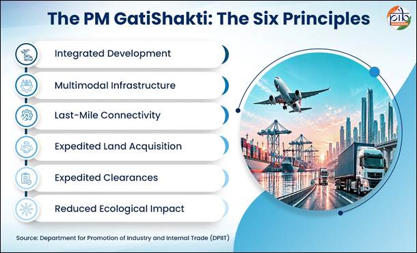
Six Guiding Principles: Integrated development, multimodal infrastructure, last-mile connectivity, faster land acquisition, minimum clearances, and lower ecological impact—to make infrastructure more efficient and sustainable.
Key Features of PM Gati Shakti:
Seven Infrastructure Engines: Roads, Railways, Ports, Waterways, Airports, Mass Transport, and Logistics Infrastructure, to strengthen multimodal connectivity.
Scheme Convergence: It brings together infrastructure schemes of different ministries and states, like Bharatmala, Sagarmala, inland waterways, dry/land ports, and UDAN.
Public Data Access: The PM Gati Shakti Public platform gives access to 230 approved datasets for site suitability, connectivity mapping, alignment planning, and compliance checks.
ITLA and Integrated Transport Planning:
Institutional Support: The Integrated Transport & Logistics Authority (ITLA) complements PM Gati Shakti by providing a dedicated mechanism for long-term transport planning and coordination.
National Transport Master Plan: ITLA will prepare a National Transport Master Plan with a 10+ year horizon, covering major transport and logistics sectors.
Project Appraisal: ITLA will review sectoral and annual transport plans and do technical appraisals of projects costing ₹500 crore or more and monitor their implementation.
National Transport Data Repository (NTDR): ITLA will create NTDR by integrating data from FASTag, Vahan, GSTN e-way bills, etc.
How PM Gati Shakti Works:
It works through a 3-tier framework supported by a GIS-based digital platform:
EGoS (Empowered Group of Secretaries): Chaired by the Cabinet Secretary, it oversees implementation and approves changes in the National Master Plan.
NPG (Network Planning Group): Heads of Network Planning Divisions from the infra-ministries examine proposals to ensure unified planning and integration and monitor developments.
TSU (Technical Support Unit): Domain experts who support evaluation and assist the Logistics Division, which acts as the PM Gati Shakti Secretariat.
Digital Support: The framework is backed by a digital platform providing geospatial data, satellite imagery, and analytical tools for integrated planning.
How PM Gati Shakti is Transforming Infrastructure Planning Through Digital Tech:
PM Gati Shakti is changing infrastructure planning from isolated, siloed projects to integrated, data-driven planning using digital tools.
Integrated GIS-Based Planning: All infrastructure networks, geographical features, demographic data, and economic zones are brought on a single GIS platform for coordinated planning.
Spatial & Analytical Tools: The platform allows project mapping, proximity analysis, identification of Go/No-Go areas, and clearance assessments, which improves decision-making.
Mapping Economic and Logistics Nodes: Economic zones like textile, pharma clusters, defense corridors, electronic parks, industrial corridors, fishing, and agri clusters are mapped along with logistics nodes to identify gaps. For example, the Khagaria–Purnea corridor in Bihar will connect 5 economic nodes and 11 logistics nodes.
Private Sector Access: Since October 2025, the platform has been opened to private players through BISAG-N’s Query-Based Analytics, giving regulated access to non-sensitive data for site suitability and investment planning.
Digital Monitoring and Data Management: The NMP Dashboard enables multi-sector project monitoring, while DUMS allows decentralized, real-time updating of infrastructure data.
Conclusion
In five years, PM Gati Shakti has evolved from a mapping platform into a transformative framework for infrastructure planning in India.
Its convergence with schemes like Bharatmala, Sagarmala, and UDAN, focusing on seven infrastructure engines and six guiding principles, and now private sector access, is strengthening multimodal and last-mile connectivity while minimizing cost, clearances, and ecological impact.
Reference: